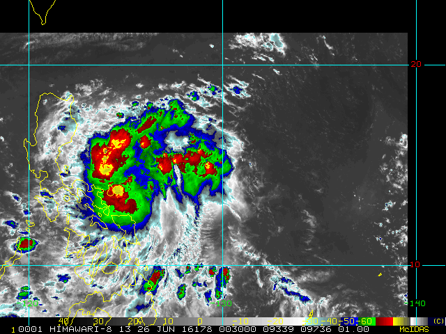
Tropical Disturbance INVEST 97W has appeared more organized overnight as it quickly makes its way across the Philippine Sea towards Luzon. Rainfall associated with the system has begun to affect areas in the Eastern Visayas and Eastern Bicol Region.
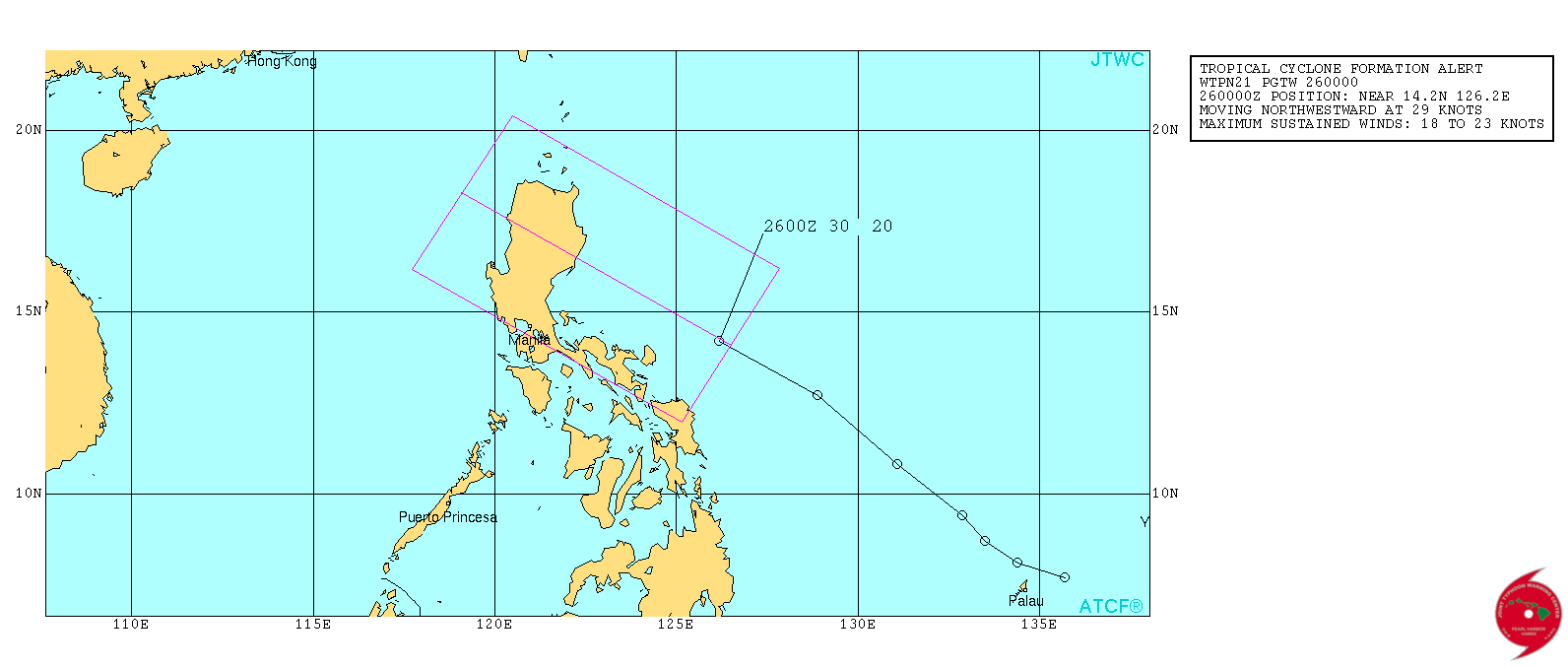
The Joint Typhoon Warning Center (JTWC) has issued a Tropical Cyclone Formation Alert (TCFA) this morning as follows: THE AREA OF CONVECTION PREVIOUSLY LOCATED NEAR 8.2N 133.7E, IS NOW LOCATED NEAR 14.2 126.2E, APPROXIMATELY 300 NM EAST OF MANILA, PHILIPPINES. RECENT ENHANCED INFRARED SATELLITE ANIMATION INDICATES PERSISTENT DEEP CONVECTION ASSOCIATED WITH A DEVELOPING LOW-LEVEL CIRCULATION CENTER (LLCC) RAPIDLY MOVING TOWARD THE NORTHWEST. A 251926z 91GHZ SSMIS PASS INDICATES DEEP CONVECTION WRAPPING AROUND THE NORTH AND NORTHWEST SIDE OF THE BROAD LOW-LEVEL CIRCULATION THAT HAS NOT COMPLETELY CLOSED OFF ON THE SOUTHERN FLANK, LIKELY DUE TO THE RAPID FORWARD MOTION OF THE SYSTEM. THE UPPER-LEVEL ENVIRONMENT IS FAVORABLE FOR DEVELOPMENT WITH FAIR OUTFLOW THAT MAY IMPROVE AS THE SYSTEM NEARS A MID-LATITUDE JET. VERTICAL WIND SHEAR IS ESTIMATED TO BE A LIGHT 10-15 KNOTS. GIVEN THE FAVORABLE ENVIRONMENT, A TROPICAL CYCLONE COULD FORM QUICKLY IF THE SYSTEM SLOWS DOWN ENOUGH FOR THE CONVECTION TO ORGANIZE AROUND THE LLCC. GLOBAL MODELS ONLY INDICATE A WEAK CIRCULATION MOVING INTO LUZON IN THE NEXT 24 HOURS. MAXIMUM SUSTAINED SURFACE WINDS ARE ESTIMATED AT 17 TO 22 KNOTS. MINIMUM SEA LEVEL PRESSURE IS ESTIMATED TO BE NEAR 1006 MB. DUE TO IMPROVED CONVECTIVE ORGANIZATION AND FAVORABLE ENVIRONMENT, THE POTENTIAL FOR THE DEVELOPMENT OF A SIGNIFICANT TROPICAL CYCLONE WTIHIN THE NEXT 24 HOURS IS HIGH. INVEST 97W has been located at 14.2N 126.2E, about 225 km East-Northeast of Catanduanes. Bearing 18-23 Knots (33-43 KPH) winds, the system is forecast to move to the West-Northwest towards Luzon. Areas in Luzon should expect rainfall in the coming hours up until the next 2-3 days as the system approaches land. Orographic (landmass) effects could increase rainfall amounts, especially areas near mountain ranges. Manila TC has the disturbance having a medium chance (56%) of becoming a Tropical Cyclone within the next 24 hours. |
Archives
July 2016
AuthorThis is the official blog page of Manila Typhoon Center. All the latest advisories from ManilaTC will be coursed here should the Facebook page be inaccessible for any reason. Categories
All
|
Manila Typhoon Center - Your online resource for typhoon updates.
 RSS Feed
