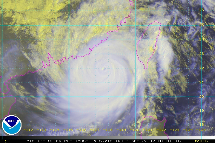
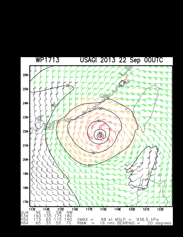
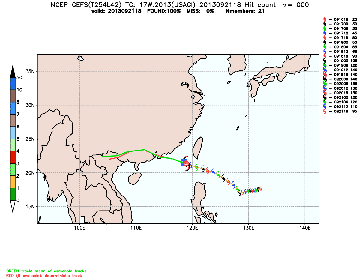
 The strongest tropical cyclone on the planet for this year (so far, we still have 4 months) has weakened into a Category 3 Typhoon after undergoing a EWRC (Eyewall replacement cycle). Latest data shows that the Typhoon is reintensifying after retaining an Eye. For a full explanation of a EWRC, see this Wikipedia article. Click Here. USAGI has also left the Philippine AoR last night, after making landfall over Itbayat Island in the Batanes Island Group as a Category 5 Super Typhoon. It was the strongest typhoon to hit Batanes (as typhoon-prone as they are) since 1987. USAGI (Odette) is now headed for a collision course with Hong Kong as of the moment. More info at the jump, so click Read More. 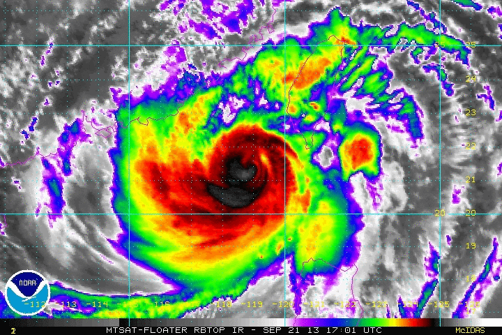 Click to view satellite loop Click to view satellite loop CURRENT AGENCY WARNINGS CMA-Beijing has hoisted a RED TYPHOON WARNING, the highest alert on its Typhoon warning scale, meaning that in 6 hours, tropical cyclone is likely to affect or has affected the area, bringing average wind speed of scale 12 on off shore & land or gust of scale 14; and this condition is to continue. The warning states as follows: In the next 24 hours from 8:00 today, there will be high wind with scale 9-11 and gust of 12-13 affecting Taiwan Strait, east of Taiwan, northeastern South China Sea, Bashi Channel, southern coast of Taiwan. Heavy rain or rainstorm with isolated severe rainstorm is forecasted to hit coast of Zhejiang, coast of Fujian, eastern coast of Guangdong, and Taiwan. The HongKong Observatory has also raised the STRONG WIND SIGNAL NUMBER 3. This means that winds with mean speeds of 41 to 62 kilometres per hour are expected in HongKong. In its latest advisory, HKO advised that: In the past few hours, Usagi edged steadily towards the vicinity of the Pearl River Estuary. According to the present forecast track, there is a high chance Usagi would make landfall to the east of Hong Kong and will be closest to the territory around tonight and tomorrow morning. Winds are now generally from the north and most parts of the territory are sheltered. However as Usagi gradually edges closer to Hong Kong, local winds will strengthen gradually. The Observatory will consider issuing the TROPICAL CYCLONE SIGNAL NUMBER 8 this afternoon to this evening. All PAGASA-Manila Typhoon Warnings have been lowered. At 8 am today Manila time, The eye of Typhoon USAGI (Odette) was last located at 21.8°N, 117.9°E... about 395 km East-Southeast of Hong Kong SAR, China... ODETTE (Usagi) is moving on a WEST-NORTHWEST track at 19 kph. USAGI (Odette) remains as a strong Category 3 Typhoon, with maximum sustained winds of 185 kph with gusts reaching 220 kph. INTENSITY ESTIMATES BY WEATHER AGENCIES HKO-Hongkong -- Max 165 kph (10 min-average) CMA-Beijing -- Max 175 kph (10 min-average) CWB-Taiwan -- Max 165 kph Gust 200 kph (10 min-average) JMA-Tokyo -- Max 160 kph Gust 195 kph (10 min-average) JTWC-Hawaii -- Max 190 kph Gust 205 kph (1 min-average) KMA-Seoul -- Max 180 kph Gust 220 kph (10 min-average) PAGASA-Manila -- Unavailable, Outside of Philippine AoR
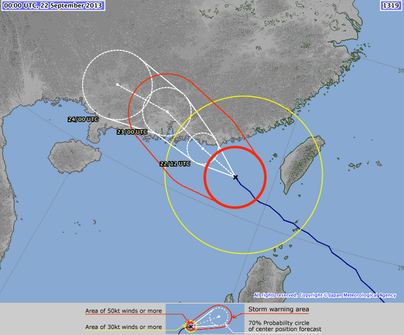
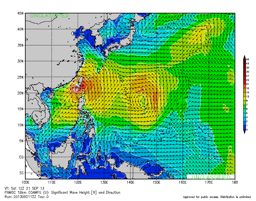
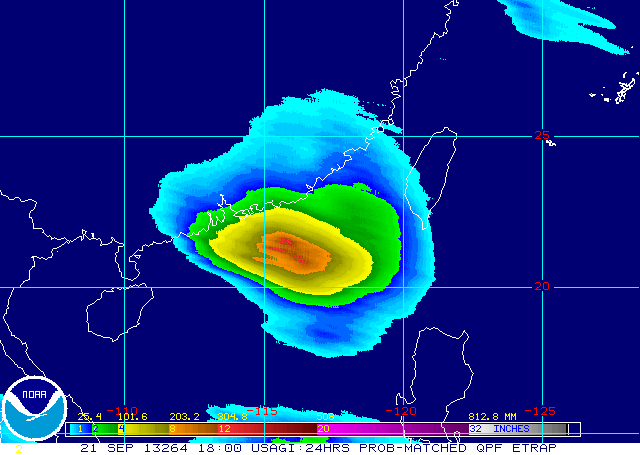
 ODETTE (Usagi) is forecast to track WEST-NORTHWEST in response to a High Pressure ridge to its north, towards the Guangdong, China coast near or over HongKong by late Sunday night going into early Monday as either as a low-end Category 3 or high Category 2 Typhoon. Winds of up to 60kph extend to a radius of 415 km.... with 110 kph winds extending out to 200 km... The region of Typhoon force winds are in an area 115 km from the eye. Maximum wave height is 45 feet. Rainfall estimates are 5-15 mm/hr (Moderate to Intense) within the 800 km diameter of the Typhoon. The Southwest Monsoon is being enhanced by the system and may cause Moderate to at times Heavy Rain, including Thunderstorms over Metro Manila, Mindoro-Marinduque-Palawan (MIMAROPA), and Cavite-Laguna-Batangas-Rizal-Quezon (CALABARZON). A GALE WARNING is also in force from PAGASA, covering the following areas due to the "Habagat". -- The western seaboard of Luzon (Ilocos Sur, Pangasinan, La Union, Western coast of Ilocos Norte, Zambales, Bataan, Metro Manila, Cavite, Mindoro Occidental, Western Coast of Batangas and Palawan)... Cloudy skies with scattered to widespread rainshowers and thunderstorms with winds of 52 to 71 kph, Seas will be Rough to very rough with waves 3.4 to 5.5 m high -- The northern and eastern seaboards of Northern Luzon and the eastern seaboard of Central Luzon (Batanes, Calayan, Babuyan, northern coast of Ilocos Norte, Caayan, Isabela, Aurora)... Cloudy skies with scattered rainshowers and thunderstorms with winds of 52 to 63 kph, Seas will be Rough to very rough with waves 3.4 to 4.5 meters high Fishing boats and other small seacrafts are advised not to venture out into the sea while larger sea vessels are alerted against big waves. #ManilaTC #UsagiWP #OdettePH #TyphoonWatch #HabagatWatch
Data gathered from JTWC-Hawaii, JMA-Tokyo, HKO-Hongkong, PAGASA-Manila, CWB-Taiwan, CMA-Beijing, and KMA-Seoul.
Images and Animation: NOAA NESDIS and SSD Divisions, JTWC-Hawaii, JMA-Tokyo, HKO-Hongkong, Cyclocane, Massachussetts Inst. of Technology, NOAA ESRL, FNMOC, NASA TRMM, NOAA ETRAP. |
Archives
July 2016
AuthorThis is the official blog page of Manila Typhoon Center. All the latest advisories from ManilaTC will be coursed here should the Facebook page be inaccessible for any reason. Categories
All
|
Manila Typhoon Center - Your online resource for typhoon updates.


 RSS Feed
