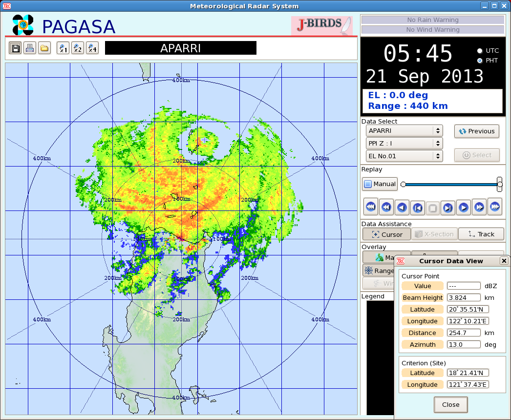
 The radar image on the right shows the Eye of Super Typhoon ODETTE (Usagi) causing a direct hit on the Islands of Batanes around 5-6 am Manila Time. At 6 am today Manila time, The eye of Super Typhoon ODETTE (Usagi) was last located at the vicinity of the Batanes Group of Islands or at 20.5°N, 122.2°E... 240 km North-Northeast of Aparri, Cagayan... ODETTE (Usagi) is moving on a WEST-NORTHWEST TRACK at 20 kph. Image courtesy of PAGASA Northern Luzon - Aparri Radar. More at the jump, so click READ MORE!  Click to view satellite loop Click to view satellite loop PAGASA TYPHOON WARNING SIGNALS (as of 5 am Warning) SIGNAL NUMBER 4 -- Batanes Group of Islands... meaning winds exceeding 185 kph are now being experienced SIGNAL NUMBER 3 -- Calayan Group of Islands and Babuyan Group of Islands... meaning winds from 101 to 185 kph are now being experienced SIGNAL NUMBER 2 -- Cagayan, Ilocos Norte, and Apayao... meaning winds of 61-100 kph are now being experienced SIGNAL NUMBER 1 -- Abra, Kalinga, Isabela, Northern Aurora, Quirino, Nueva Vizcaya, Benguet, La Union, Ilocos Sur, Mt. Province, and Ifugao... meaning winds of 45-60 kph are are now being experienced
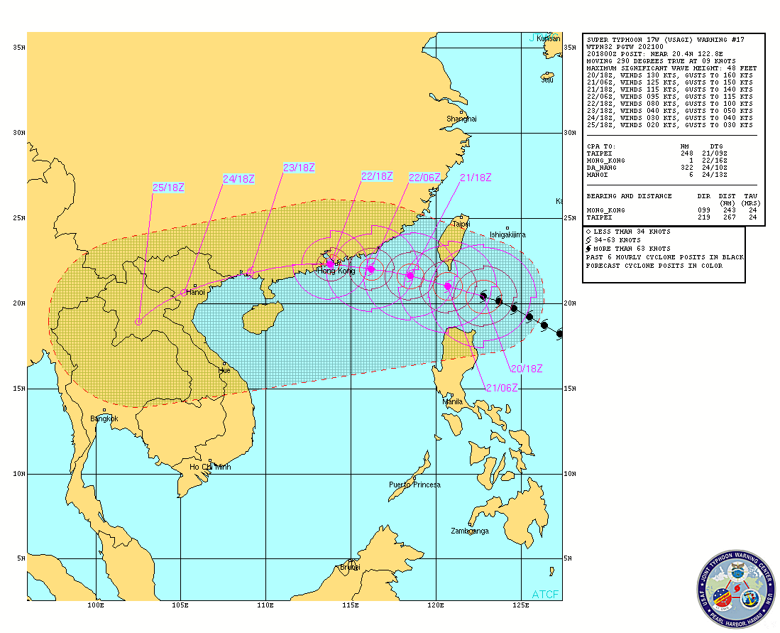
 INTENSITY ESTIMATES BY WEATHER AGENCIES PAGASA-Manila -- Max 215 kph Gust 250 kph (10 min-average) CMA-Beijing -- Max 210 kph (10 min-average) JMA-Tokyo -- Max 195 kph Gust 280 kph (10 min-average) KMA-Seoul -- Max 190 kph Gust 235 kph (10 min-average) JTWC-Hawaii -- Max 240 kph Gust 300 kph (1 min-average) CWB-Taiwan -- Max 200 kph Gust 240 kph (10 min-average) HKO-Hongkong -- Max 205 kph (10 min-average) ODETTE (Usagi) is still being forecast to track to a more WESTERLY track in response to a building High Pressure ridge to the north, towards the Southern China coast near or over HongKong. Most agencies have ODETTE (Usagi) making a direct hit on Hong Kong as a strong Category 3 or 4 system, ranging from 175 to 210 kph. Gale force winds extending to a radius of 560km (1,120 km diameter)... with Typhoon force winds extending out to 170 km. Maximum wave height is 48 feet. Rainfall estimates are 10-20 mm/hr (Heavy to Intense) within the 800 km diameter of the Typhoon. The Southwest monsoon is being enhanced by the system and as a result, A GALE WARNING is still in force from PAGASA, covering the following areas:
#ManilaTC #OdetteTC #UsagiWP #TyphoonWatch #FloodWatch #HabagatWatch |
Archives
July 2016
AuthorThis is the official blog page of Manila Typhoon Center. All the latest advisories from ManilaTC will be coursed here should the Facebook page be inaccessible for any reason. Categories
All
|
Manila Typhoon Center - Your online resource for typhoon updates.


 RSS Feed
