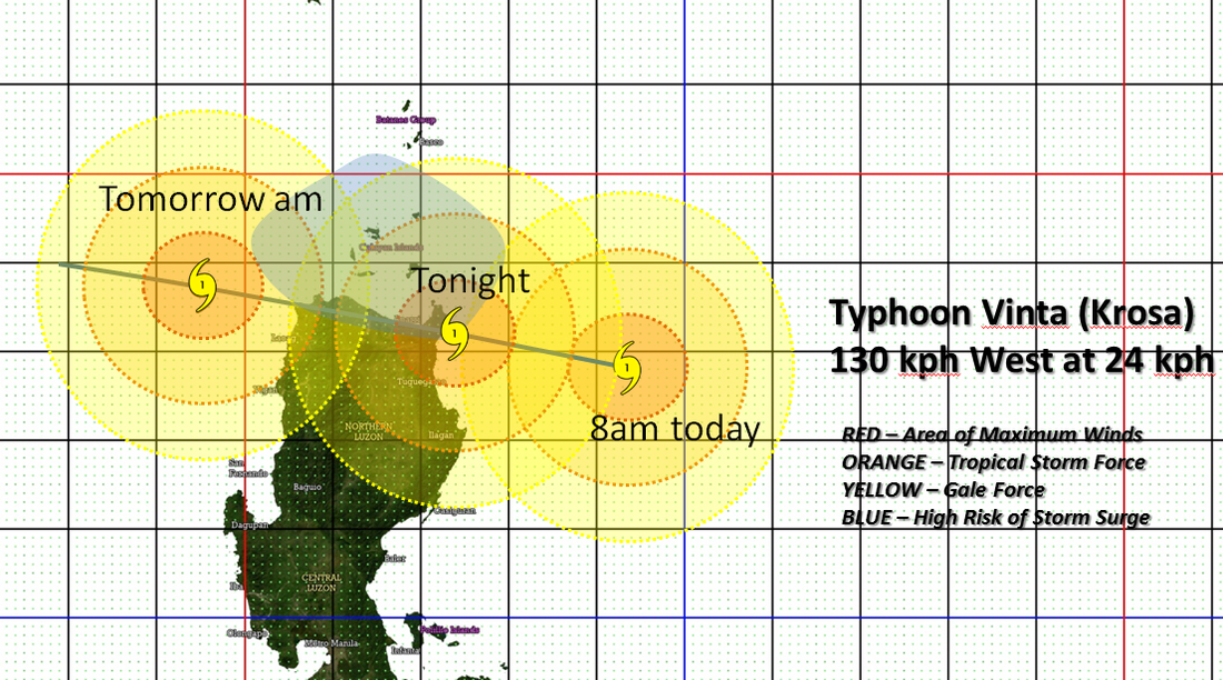
 Storm VINTA (Krosa) is now bearing down on Cagayan Province, potentially making landfall along the NE corner of Northern Luzon later today... The system is now a TYPHOON on the 1 min scale with 130 kph winds and a SEVERE TROPICAL STORM in JMA-Tokyo's latest advisory.
PAGASA STORM WARNING SIGNALS AS OF 5 AM WARNING STORM SIGNAL #3 -- Cagayan, and Apayao... winds in excess of 100kph expected within 18 hours. STORM SIGNAL #2 -- Calayan Group of Islands, Babuyan Group of Islands, Isabela, Kalinga, Ilocos Norte, Ilocos Sur, Abra, Mt. Province ... winds between 61 to 100 kph expected within 24 hours. STORM SIGNAL #1 -- La Union, Pangasinan, Benguet, Ifugao, Nueva Vizcaya, Nueva Ecija, Quirino, Aurora, Batanes Group of Islands ... winds of 45-60 kph expected within 36 hours. At 8 am today (00Z), the eye of VINTA (Krosa) has been located at 17.8°N, 124.4°E, about 285 kms East of Tuguegarao, Cagayan. Maximum Winds of 120 KPH (65 Knots) and gusts of 150 KPH (85 Knots)... VINTA (Krosa) is currently moving to the WEST at 24 KPH in the general direction of Cagayan province... VINTA (Krosa) may possibly make landfall along the eastern coast of Cagayan later today or early tonight. All concerned should follow or track the severe weather potential of the storm not just the track of the storm center. Please take note that any shift in the movement of VINTA (Krosa) to the north or south of the forecast track can make a HUGE difference on the storm's potential effects in your area. Residents and Interests on Luzon island should keep watch on the path of this storm, especially those preparing to travel for the All Saints/All Souls day holiday this weekend. ManilaTC |
Archives
July 2016
AuthorThis is the official blog page of Manila Typhoon Center. All the latest advisories from ManilaTC will be coursed here should the Facebook page be inaccessible for any reason. Categories
All
|
Manila Typhoon Center - Your online resource for typhoon updates.
 RSS Feed
