This page has been revised to reflect the new PAGASA Public Storm Warning Signals effective May 1, 2015 by virtue of Memorandum Circular No.3.
The PAGASA Public Storm Warning Signals
The Philippine Atmospheric, Geophysical and Astronomical Services Administration is a Philippine national institution dedicated to provide flood and typhoon warnings, public weather forecasts and advisories, meteorological, astronomical, climatological, and other specialized information and services primarily for the protection of life and property and in support of economic, productivity and sustainable development. The government agency was created on December 8, 1972 by virtue of Presidential Decree No. 78 reorganizing the Philippine Weather Bureau into PAGASA.
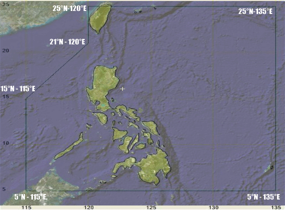
The Philippine Area of Responsibility
|
The Philippine archipelago, which is surrounded by water, lies at the western rim of the Pacific Ocean, north of the equator and about a thousand kilometers from the Asian Mainland.
It is bounded on the west by the South China Sea/West Philippine Sea, on the east by the Pacific Ocean, on the north by the Bashi Channel and on the south by the Sulu and Celebes Seas. It refers to the designated area in the northwestern Pacific where PAGASA is tasked to monitor tropical cyclone occurrences. The Philippine Area of Responsibility (PAR) is bounded by the black lines joining the following points:
|
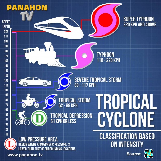
PAGASA TROPICAL CYCLONE CATEGORIES
|
Tropical Depression (TD) has maximum sustained winds of up to 61 kilometers per hour, equivalent to 33 nautical miles per hour or more.
Tropical Storm (TS) packs 62 to 117 kilometers per hour. Meanwhile, a Severe Tropical Storm will only be applicable for the International Warning for Shipping, and will not be used for general public dissemination unlike the other categories. Typhoon (TY) is used in identifying a tropical cyclone with wind speeds 118 to 220 kilometers per hour or 64 to 120 knots. Super Typhoon (STY) has maximum sustained winds of more than 220 kilometers per hour. STY is as powerful as 120 nautical miles per hour or more. |
What are storm signals?
PAGASA employs a numbered warning system from 1 the lowest to 5 the highest depending on the wind speeds a locality is about to experience and the lead time before such conditions are to be experienced.
Important Notes to Consider:
- When any Public Storm Warning Signal Number is hoisted or put in effect for the first time, the corresponding meteorological conditions are not yet prevailing over the locality. This is because the purpose of the signal is to warn the impending occurrence of the given meteorological conditions.
- The approximate lead time to expect the range of the wind speeds given for each signal number is valid only when the signal number is put in effect for the first time.
- Thus, the associated meteorological conditions are still expected in at least 36 hours when PSWS #1 is put in effect initially; in at least 24 hours with PSWS #2; in at least 18 hours with PSWS #3; and in at least 12 hours with PSWS #4 and #5. The lead time shortens correspondingly in the subsequent issues of the warning bulletin when the signal number remains in effect as the tropical cyclone comes closer.
- It is also important to remember that tropical cyclones are constantly in motion; generally towards the Philippines when PAGASA is issuing the warning. Therefore, the Public Storm Warning Signal Number over a threatened/ affected locality may be sequentially upgraded or downgraded.
- This means that PSWS #1 may be be upgraded to PSWS #2, then to PSWS #3 and to PSWS #4 as necessary when a very intense typhoon is approaching or downgraded when the typhoon is moving away.
- However, in case of rapid improvement of the weather condition due to the considerable weakening or acceleration of speed of movement of the tropical cyclone moving away from the country, the downgrading of signal may jump one signal level. For example, PSWS #3 may be downgraded to PSWS #1 or all signals from PSWS #2 may be lowered.
- The delineation of areas for a given signal number is based on the intensity, size of circulation and the forecast direction and speed of movement of the tropical storm or typhoon at the time of issue of the warning bulletin.
- The change in intensity, size of circulation or movement of the tropical cyclone also determines the change in the PSWS number over a given locality.
PUBLIC STORM WARNING SIGNAL 1 (PSWS #1)
|
WEATHER CONDITIONS
DISASTER PREPAREDNESS MEASURES
|
AGRICULTURAL IMPACTS
- Twigs and branches of small trees may be broken.
- Some banana plants may be tilted or uprooted.
- Rice crops in flowering stage may suffer significant damage.
- Minor damage to banana trees [Musa spp.] and near-coastal agriculture, primarily from salt spray.
- Some small dead limbs, ripe coconuts, and dead palm fronds blown from trees.
- Some fragile and tender green leaves blown from trees such as papaya [Carica papaya] and fleshly broad leaf plants.
PROPERTY IMPACTS
- Some houses of very light materials may be partially unroofed.
- Only very light or no damage may be sustained by areas affected.
- Damage done to only the flimsiest lean-to type structures.
- Unsecured light signs blown down.
COASTAL AND SURGE IMPACTS
- On windward coasts, sea level rise of 2-4 ft (0.7-1.2 m) above normal in open bays and inlets due to storm surge and wind-driven waves.
- Breaking waves inside bays can reach 4-6 ft (1.2-1.8 m); 1-2 ft (0.3-0.7 m) of additional water over reefs.
- Very rough surf at reef margin with strong along-shore currents (rip tides) inside reefs.
PUBLIC STORM WARNING SIGNAL 2 (PSWS #2)
|
WEATHER CONDITIONS
DISASTER PREPAREDNESS MEASURES
|
AGRICULTURAL IMPACTS
- Some coconut trees may tilt; some of them may break.
- Few big trees may be uprooted.
- Many banana plants may be downed.
- Rice and corn crops may be affected.
- Moderate damage to banana trees, papaya trees, and most fleshy crops.
- Large dead limbs, ripe coconuts, nay dead palm fronds, some green leaves, and small branches are blown from tree.
|
PROPERTY IMPACTS
|
COASTAL AND SURGE IMPACTS
|
PUBLIC STORM WARNING SIGNAL 3 (PSWS #3)
- PSWS #3 is valid once the storm reaches Typhoon category.
- Warning roughly covers Category 1 and Category 2 typhoons on the Saffir-Simpson Scale.
- This warning notes that the winds may bring moderate to heavy damage may be experienced, particularly in the agricultural and industrial sectors.

|
WEATHER CONDITIONS
DISASTER PREPAREDNESS MEASURES
|
AGRICULTURAL IMPACTS -- Note: Impacts vary as typhoon winds increases
In General:
In General:
- Many coconut trees may be broken or destroyed.
- Almost all banana plants may be downed and a large number of trees may be uprooted.
- Rice and corn crops may suffer heavy losses.
|
For Typhoon winds 120 to 145 KPH (10-minute average)
|
For Typhoon winds 146 to 170 KPH (10-minute average)
|
PROPERTY IMPACTS -- Note: Impacts vary as typhoon winds increases
In General
In General
- Majority of light material houses may be unroofed or destroyed.
- There may be considerable damage to structures of light to medium construction.
- There may be widespread disruption of electrical power and communication services.
|
For Typhoon winds 120 to 145 KPH (10-minute average)
|
For Typhoon winds 146 to 170 KPH (10-minute average)
|
COASTAL AND SURGE IMPACTS -- Note: Impacts vary as typhoon winds increases
|
For Typhoon winds 120 to 145 KPH (10-minute average)
|
For Typhoon winds 146 to 170 KPH (10-minute average)
|
PUBLIC STORM WARNING SIGNAL 4 (PSWS #4)
- PSWS #4 is valid once the storm reaches Typhoon category.
- Warning roughly covers Category 3 and Category 4 typhoons on the Saffir-Simpson Scale.
- This warning notes that the winds may bring very heavy damage to affected communities.
|
WEATHER CONDITIONS
DISASTER PREPAREDNESS MEASURES
|
AGRICULTURAL IMPACTS -- Note: Impacts vary as typhoon winds increases
In General
In General
- Coconut plantations may suffer extensive damage.
- Many large trees may be uprooted.
- Rice and corn plantation may suffer severe losses.
|
For Typhoon winds 171 to 195 KPH (10-minute average)
|
For Typhoon winds 195 to 220 KPH (10-minute average)
|
PROPERTY IMPACTS -- Note: Impacts vary as typhoon winds increases
In General
In General
- Most residential and institutional buildings of mixed construction may be severely damaged.
- Electrical power distribution and communication services may be severely disrupted.
|
For Typhoon winds 171 to 195 KPH (10-minute average)
|
For Typhoon winds 195 to 220 KPH (10-minute average)
|
COASTAL AND SURGE IMPACTS -- Note: Impacts vary as typhoon winds increases
|
For Typhoon winds 171 to 195 KPH (10-minute average)
|
For Typhoon winds 195 to 220 KPH (10-minute average)
|
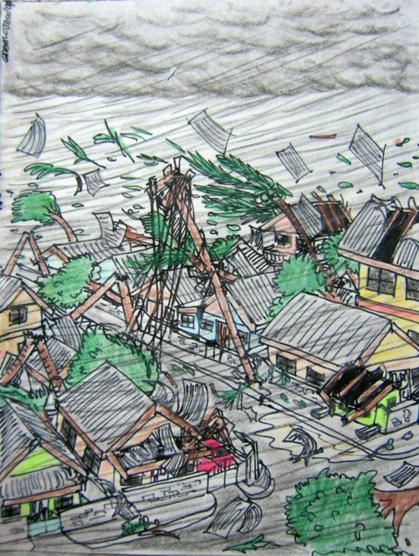
PUBLIC STORM WARNING SIGNAL 5 (PSWS #5)
- The highest warning, PSWS #5 is valid once the storm reaches Super Typhoon category.
- Warning roughly covers Category 5 typhoons on the Saffir-Simpson Scale.
- This warning notes that the winds may bring widespread and devastating damage to affected communities.
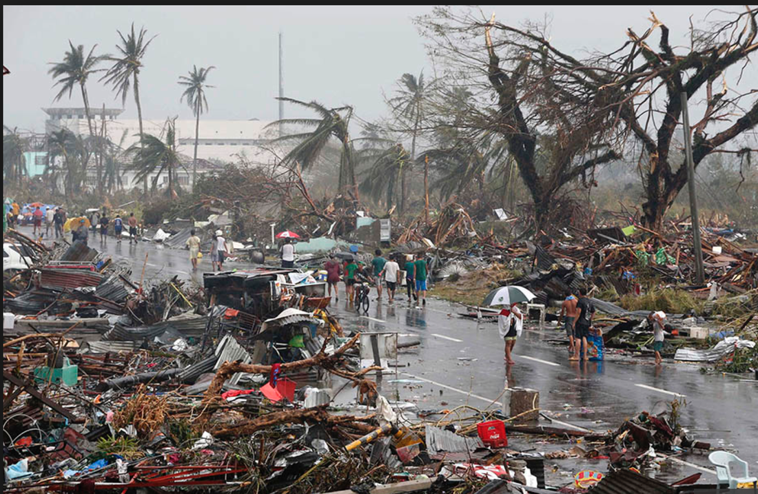
Super Typhoon Haiyan (Yolanda), 2013
|
WEATHER CONDITIONS
DISASTER PREPAREDNESS MEASURES
|
AGRICULTURAL IMPACTS
- Total damage to banana plantation.
- Most tall trees are broken, uprooted, or defoliated.
- Coconut trees are stooped, broken, or uprooted.
- Few plants and trees survive.
- Shrubs and trees up to 100% defoliated; numerous large trees blown down.
- Up to 100% of palm fronds bent, twisted, or blown off; numerous crowns blown from palm trees; virtually all coconuts blown from trees.
- Most bark and considerable pulp removed from trees.
- Most standing trees are void of all but the largest branches, which are very stubby in appearance and severely sandblasted.
PROPERTY IMPACTS
- Almost total damage to structures of light materials, especially in highly exposed coastal areas.
- A high percentage of framed homes will be destroyed, with total roof failure and wall collapse.
- Complete roof failure on many buildings. Total failure of non-concrete reinforced roofs.
- Severe and extensive window and door damage.
- Extensive glass failure due to impact of flying debris and explosive pressure forces during extreme gusts.
- Most residential and institutional buildings of mixed construction may be severely damaged.
- Extensive or total destruction to non-concrete residences and industrial buildings.
- Some structural damage to concrete structures, especially from large debris, such as cars, large appliances, etc.
- Electrical power distribution and communication services severely disrupted.
- Severe damage to some solid concrete power poles, to numerous reinforced hollow-spun concrete power poles, to many steel towers, and to virtually all wooden poles; all secondary power lines and most primary power lines downed.
- Power outages will last for weeks to possibly months.
- All signboards blown down.
- Many well-constructed storm shutters ripped from structures.
- Some fuel storage tanks rupture.
- Nearly all construction cranes blown down.
- Air full of very large and heavy projectiles and debris.
- Fallen trees and power poles will isolate residential areas.
- Most of the area will be uninhabitable for weeks or months.
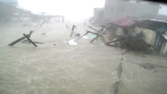
COASTAL AND SURGE IMPACTS
- On windward coasts, sea level rise of >25 ft (>7.6 m) above normal in open bays and inlets due to storm surge and wind-driven waves
- Breaking waves inside bays can be > 30 ft 99.2 m) above normal; 12-18 ft (3.7-5.5 m) of additional water over reefs. Serious inundation likely for windward coastal areas below 18 ft (5.5m) elevation.
- Very large boulders carried inland with waves.
- Extensive beach erosion.
- Extensive damage to port facilities including most loading derricks, gantry cranes, and fuel piers.
- Virtually all ships, regardless of size, torn from moorings and many sunk.
Sources:
English Wikipedia - Tropical Cyclones Portal
Guam Homeland Security - The Saffir-Simpson Typhoon Scale
Philippine Atmospheric, Geophysical, and Astronomical Services Administration (PAGASA) Website
Philippine Government Portal - The Philippine Public Storm Warning Signals
Panahon.TV Blog, Super typhoon and Signal Number 5, now part of PAGASA’s terminology
CNN Philippines, "PAGASA adds Signal No. 5", 23 May 2015
English Wikipedia - Typhoons in the Philippines
English Wikipedia - Tropical Cyclone Warnings and Watches
Image Credits: Dominic Alojado, MD, PAGASA, BBC, CNN
