PAGASA TROPICAL CYCLONE WARNING SIGNALS as of 8 AM
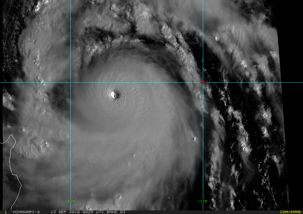
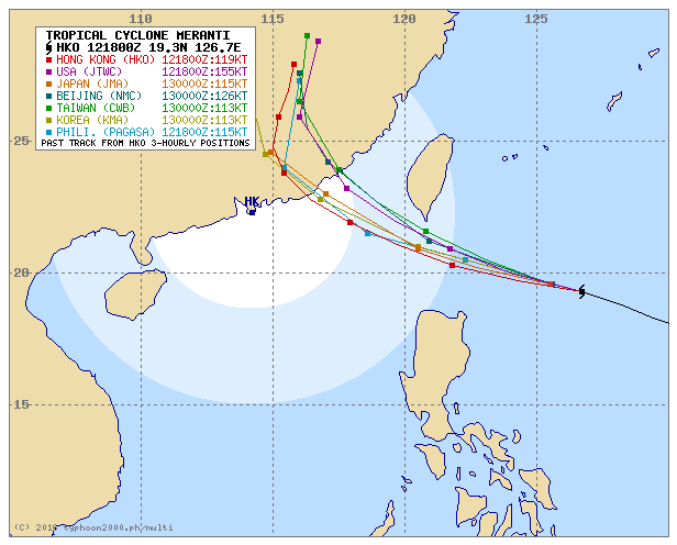
Intense Super Typhoon FERDIE (Meranti) has maintained its course and is looking to strike the Batanes Islands by early Wednesday Morning. The Joint Typhoon Warning Center has categorized the howler as a Category 5 SUPER TYPHOON. The eye of SuperTY FERDIE (Meranti) has been located at 8 am this morning at 410 km East-Southeast of Basco, Batanes or 450 km East-Northeast of Aparri, Cagayan (19.5°N, 125.7°E) and is moving to the West-Northwest at 22kph.
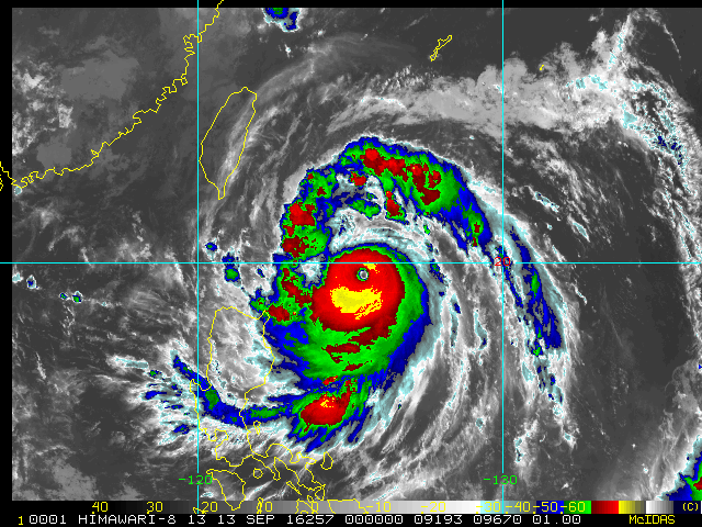
SuperTY FERDIE (Meranti) is forecast to remain on its current course and make a direct hit over the Batanes Islands by dawn Wednesday, then continue towards Southeastern China, passing close to the Southern tip of Taiwan later. ManilaTC 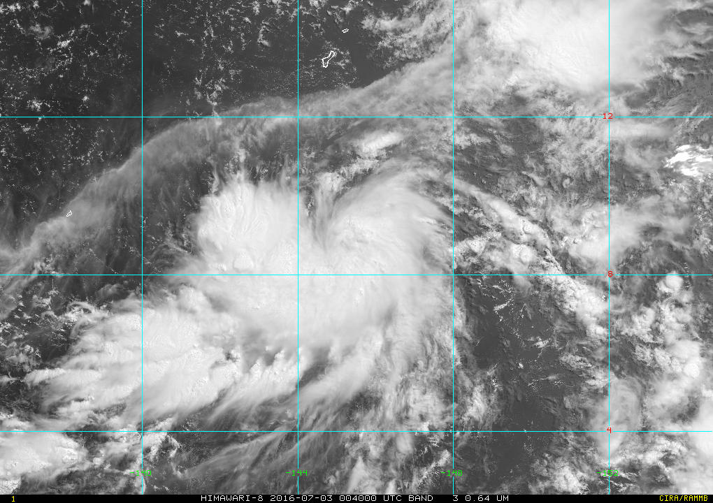 Himawari-8 image of Tropical Storm Nepartak this morning.
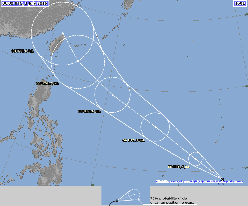
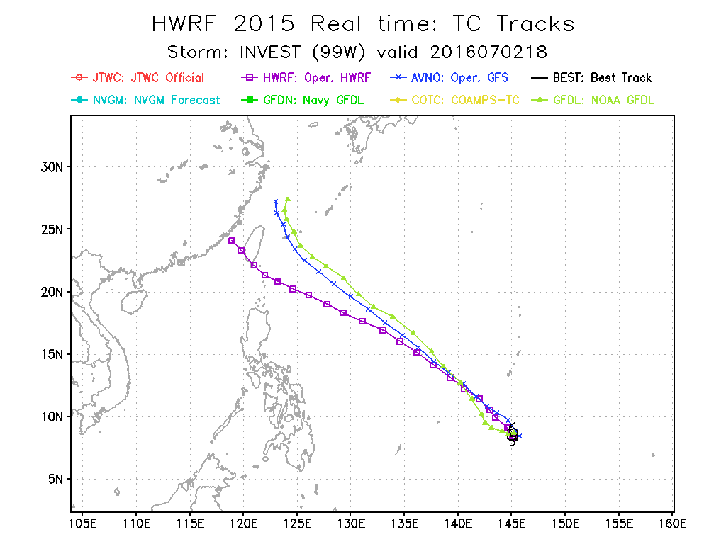
The Tropical Depression located South of Guam has intensfied into a Tropical Storm and named by the Japan Meteorological Agency (JMA) as NEPARTAK(02W). NEPARTAK is the first Tropical Storm of 2016, and breaks a 6-month streak of not having a Tropical Storm form in the WestPac and the 2nd most latest date of a named Tropical Storm, the year 1998 being the first. JMA is the designated Regional Specialized Meteorological Centre for the Western Pacific by the World Meteorological Organization. NEPARTAK NEPARTAK was last spotted at 8.7N 145.1E, about 530 km South of Guam... 770 km East of Yap State... 1110 km East of Philippines AoR. NEPARTAK has winds of 65kph near the center and gusts reaching 80 kph. The storm is forecast to move Northwest slow at first then gradually accelerate. JMA forecasts NEPARTAK(02W) to become a typhoon in about 72 hours. Initial forecast tracks and computer models show Storm NEPARTAK to move Northwest all throughout, bringing a possible threat to Taiwan and the Japanese Ryukyu Islands by weekend. It shall also enter the Philippines AoR by Tuesday. The storm wil be named by PAGASA as BUTCHOY once the storm does cross the 135E meridian. TS NEPARTAK(02W) will bring showers across Yap State and Palau due to the effect of converging monsoonal winds by tomorrow. No direct effects to the Philippines are expected based on track forecasts but its possible that NEPARTAK can bring monsoonal rains to the Philippines' western seaboard before the weekend as the storm makes its closest approach to Northern Luzon. Interests across Taiwan and the Japanese Ryukyu Islands should monitor the progress of NEPARTAK. ManilaTC
PAGASA and the Japan Meteorological (JMA) Agency has upgraded the tropical disturbance near Catanduanes into a Tropical Depression.
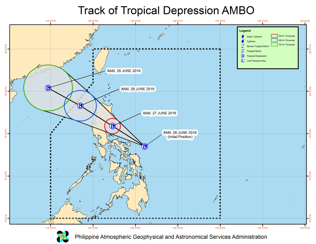
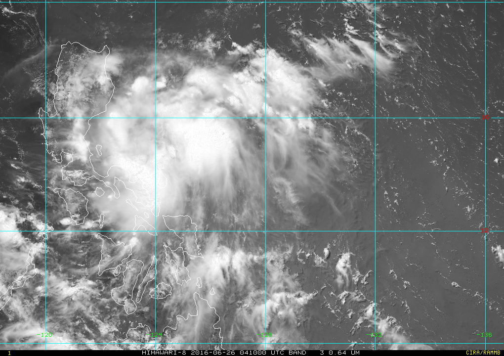
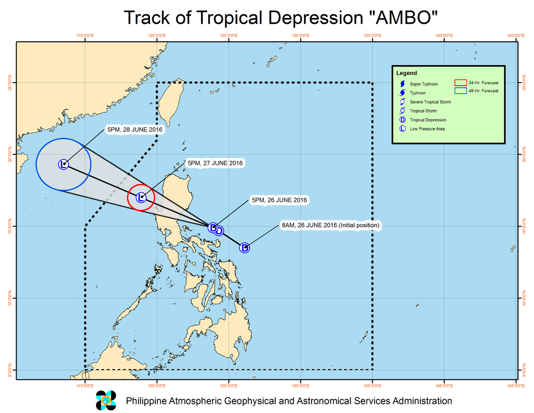
PAGASA has just issued its first warning this morning, naming the system as AMBO, with winds of 45 kph. JMA has the system at 30 knots (55 kph). AMBO is moving West-Northwest at 19 kph Tropical Cyclone Warning Signal #1 has been raised over the following provinces: Catanduanes, Camarines Norte, Camarines Sur, Northern Quezon including Polillo Islands, Aurora and Quirino. These areas will have occasional rains with occasional gusty winds. PAGASA noted that the estimated rainfall amount is from 2.5 – 10 mm per hour (moderate-heavy) within the 200 km diameter of the Tropical Depression. Likewise, occasional moderate to heavy rains is expected over Central Luzon, CALABARZON and Bicol Region beginning today. TD AMBO is expected to cross into Central Luzon tomorrow and possibly cause rainfall across the entire island of Luzon. ManilaTC
In the latest 5pm tropical cyclone warning by PAGASA, these areas are now under Tropical Cyclone Warning Signal #1 (TCWS#1)
Catanduanes, Camarines Norte, Northern Quezon including Polillo Islands, Aurora and Quirino Earlier warnings posted for Camarines Sur have been lowered. As of 6pm, the center of Tropical Depression AMBO has been placed based on NOAA ADT fix at 15.0N, 122.6E, about 70 km East of Polillio Island, Quezon or 130 km Southeast of Baler, Aurora. TD AMBO is moving to the West-Northwest at a quick 22 kph towards Aurora Province. PAGASA advised the following:
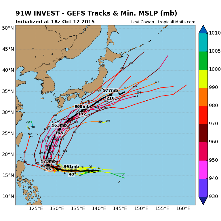
 Himawari-8 Image of TD 91W to the east of the Philippines. (Credit: Real Earth)
The tropical disturbance now passing the Guam-Southern Marianas is now upgraded by the Japan Meteorological Agency (JMA-Tokyo) into a full Tropical Depression, packing winds of 55 KPH (30 Knots) within the system,
The Joint Typhoon Warning Center has a Tropical Cyclone Formation Alert. TD 91W is now located 180 km North of Guam or 120 km West of Saipan, Marianas Islands and is tracking to the West at 15 KPH. This motion is expected to continue until Thursday. TD 91W is expected to intensify and become a Tropical Storm within the next 24 hours. Available forecast models indicate TD 91W tracking across the Philippine Sea entering the Philippine AoR by Thursday Morning. The same model runs currently indicate a Luzon approach as a Typhoon by the weekend, but recurve to the North before even striking Luzon in response to a Low to develop near Taiwan. Please do take note that model forecasts change with each run, and caution is advised in their interpretation. Even so, interests in the Philippines, Taiwan and Japan should monitor TD 91W as it progresses. Once JMA-Tokyo upgrades to a storm, 91W will be named Koppu. PAGASA will name the system as Lando once it crosses the 130E longitude. 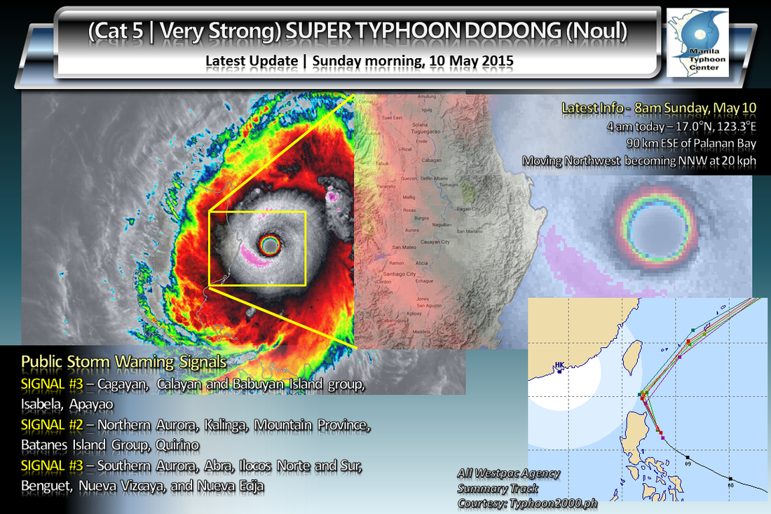 In a classic case of Rapid Intensification (RI) in the Philippine Sea, Typhoon Dodong (Noul) exploded into a 140 knot (240 kph 1-min average) howler. This prompted the Joint Typhoon Warning Center to upgrade to Super Typhoon status.
As of this writing (8 am) the 40-km wide eye of STY Dodong (Noul) was located at 17.0°N, 123.3°E, about 90 km East-Southeast off the coast of Palanan Bay, Isabela. The typhoon is currently moving to the Northwest becoming North-Northwest at 20 kph. STY Dodong (Noul) may clip the NE part of Cagayan province later today if it continues on its present course and bearing. Later on the storm will start its recurve towards the Ryukyu Islands/Okinawa region. Public storm warnings have been in place all over the Northern Luzon region with Cagayan, Calayan and Babuyan Island group, Isabela, Apayao getting the highest, at number 3. 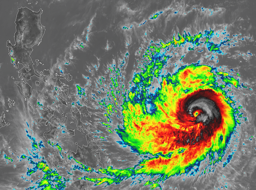 Typhoon DODONG (NOUL) as it lurks east of Samar, Philippines (Image courtesy of SSEC - Himawari 8) All eyes are now on the course of Typhoon DODONG (Noul), after it crossed the Philippine AoR this Morning. DODONG(Noul) is now a Category 2 Strong Typhoon, packing winds of 145 kph (10-min) to 165 kph (1-min) sustained with gusts reaching 185 kph... DODONG (Noul) has tracked to the West-Northwest
No Public Storm Warnings have been raised yet by PAGASA as of the latest bulletin released at 11 am today, but the agency hinted that this typhoon is expected to initially affect the Eastern Visayas and Bicol region within the next 24 – 36 hours. Available forecast tracks from agencies within the region are now projecting more of a Central Luzon landfall by weekend, possibly by Sunday. This as Computer model forecasts have been trending more west of the initially forecasted track, hinting of a much stronger-than-expected SubTropical Ridge (High) to the north of the typhoon. Typhoon DODONG (Noul) is expected to intensify further as it makes its way across the Philippine Sea towards Luzon, potential rapid intensification is not ruled out. Residents from Eastern Visayas, Bicol Region, Southern Luzon, Metro Manila, Central Luzon and Northern Luzon are advised to take initial precautions and prepare for possible further preparations later on. ManilaTC Typhoon Noul enters Philippine AoR, named as Dodong 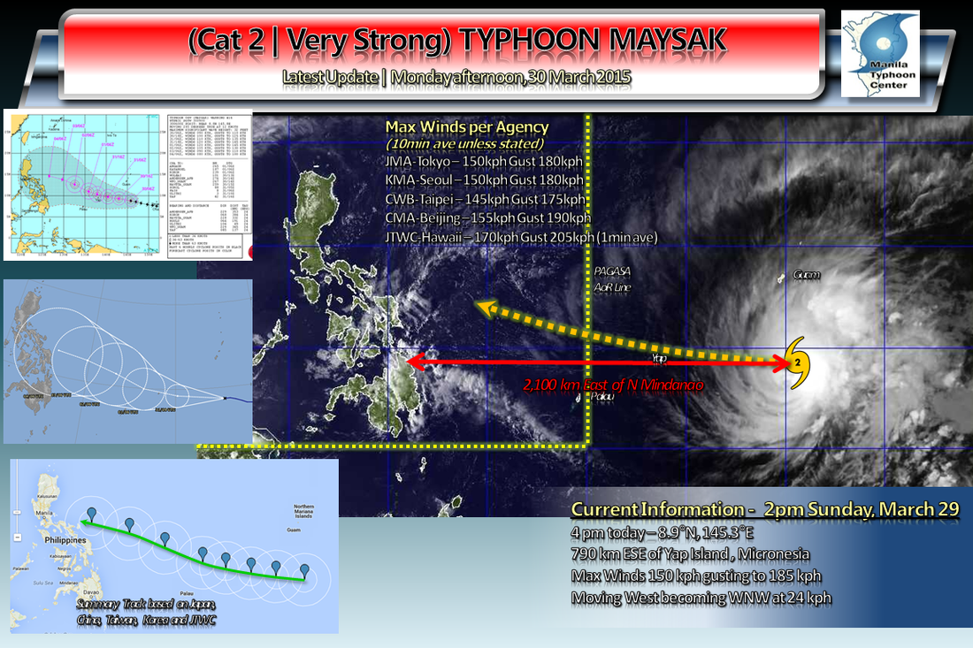  Sunset satellite image with Typhoon Maysak bearing down on Yap Island Sunset satellite image with Typhoon Maysak bearing down on Yap Island Typhoon Maysak has gradually intensified as it continues to tread on a West to West-NorthWestward direction across the Western Pacific. It is expected to pass near Faraulep Atoll early tonight, on its way to Yap Island.
The eye of the typhoon is now at 8.9°N, 145.3°E, about 95 km East-Northeast of Faraulep Atoll in Yap State... 790 km East-Southeast of Yap Island...1130 km outside PAGASA-Manila's AoR... 2100 km East of Northeast Mindanao. Maysak is now packing winds of 150 kph (10 min average)/170 kph (1 min), slightly accelerated as it is moving to the West at 24 kph. The storm is expected to pass well south of Guam tonight and move near Yap Island by the morning hours of Wednesday as a 190 kph Category 3 typhoon. Based on the forecast tracks released by the Japan, South Korea, Taiwan, and Chinese weather agencies along with the JTWC this afternoon -- Typhoon Maysak is forecast to cross the PAGASA-Manila AoR boundary line by Wednesday night. The 5 day forecast tracks bring the storm near the Bicol Region by Black Saturday afternoon. PAGASA-Manila shall name the system locally as "CHEDENG". Typhoon Maysak is expected to encounter moderately high wind shear (upper atmospheric winds) of 20-30 kts (35-50 kph) and slightly less favorable sea temperatures once it reaches the Philippine Sea by midweek, weakening the system but intensity estimates by the above-mentioned agencies still have Maysak as a still-potentially damaging 140 kph Typhoon by Saturday. Do take note that 5 days is still a bit long-range, forecasts may change from time to time. Interests in Yap State in Micronesia; Eastern Visayas, Bicol Region, CALABARZON, Central Luzon and the Manila region should continue to monitor the progress of Typhoon Maysak... as the Philippines goes on a long Holy Week holiday this weekend. Typhoon Warnings and Tropical Storm Warnings are in effect for islands in Yap State. Kindly refer to official warnings posted by the NWS in Guam. Please be advised to monitor official warnings from your local weather and disaster preparedness agencies. 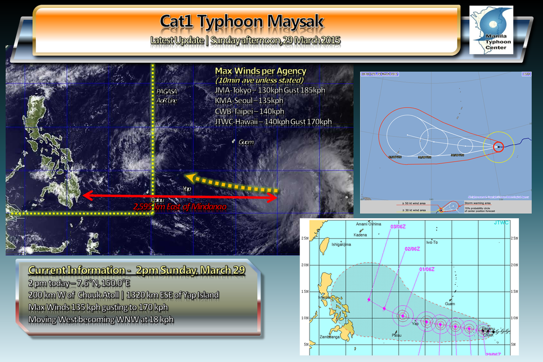 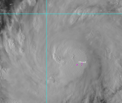 Typhoon Maysak as it passed Chuuk Atoll Sunday Morning. Typhoon Maysak as it passed Chuuk Atoll Sunday Morning. Intensifying Typhoon Maysak passed the Chuuk atoll/islands this morning, bringing heavy rain and wind to the island. Wind gusts of 111 kph were registered on Weno Airport before conking out in the storm. As of this time, we have not received any damage reports on the island.
Maysak is now the third Typhoon of the 2015 season, packing winds of 135 kph, moving West at a speed of 18 kph, away from Chuuk and moving towards Yap. It is forecast to move more to the West-Northwest and pass close if not directly hit Yap Island by Tuesday evening. Maysak is also forecast to cross the 135E Philippine AoR line by Wednesday and to be locally named as Chedeng Yap State in Micronesia, should begin to experience the outer bands of the storm by Monday night with worsening conditions as Typhoon Maysak approaches. The JTWC-US Navy expects Maysak to peak at 120 kts (1-min average) or 220 kph, JMA-Tokyo forecasts the typhoon at 175 kph (10-min average) -- both by Wednesday afternoon. Typhoon Watches and Warnings have been issued for islands in Yap and Chuuk States in Micronesia. Kindly refer to their official warnings. Residents in the Philippines should keep watch regarding the progress and track of this storm as there is an increasing likelihood that it may affect your plans for the Holy Week holiday break. ManilaTC 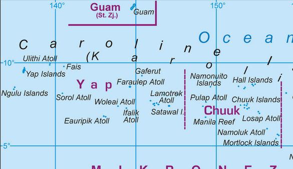 Island Map of Chuuk and Yap state Island Map of Chuuk and Yap state A TYPHOON WARNING REMAINS IN EFFECT FOR FARAULEP IN YAP STATE. TYPHOON FORCE WINDS OF 74 MPH OR MORE ARE EXPECTED IN THE NEXT 24 HOURS. A TYPHOON WARNING REMAINS IN EFFECT FOR CHUUK AND ULUL IN CHUUK STATE. TYPHOON FORCE WINDS OF 74 MPH OR MORE ARE IMMINENT OR OCCURRING FOR CHUUK AND ULUL. A TROPICAL STORM WARNING REMAINS IN EFFECT FOR SATAWAL IN YAP STATE...WHILE A TYPHOON WATCH REMAINS IN EFFECT FOR SATAWAL. A TROPICAL STORM WARNING REMAINS IN EFFECT FOR FANANU IN CHUUK STATE. DAMAGING WINDS OF 39 MPH OR MORE ARE IMMINENT OR OCCURRING. A TROPICAL STORM WARNING AND A TYPHOON WATCH REMAIN IN EFFECT FOR PULUWAT IN CHUUK STATE. DAMAGING WINDS OF 39 MPH OR MORE ARE EXPECTED THIS AFTERNOON. TYPHOON FORCE WINDS OF 74 MPH OR MORE ARE STILL POSSIBLE IF MAYSAK DEVIATES SOUTHWARD. A TYPHOON WATCH REMAINS IN EFFECT FOR WOLEAI...FAIS...ULITHI AND YAP IN YAP STATE. TYPHOON FORCE WINDS OF 74 MPH OR MORE ARE POSSIBLE IN THE NEXT 48 HOURS. Refer to the following links for the complete advisory from NWS-Guam
Typhoon Maysak Local Statement Typhoon Maysak Public Advisory |
Archives
September 2016
Categories |
Manila Typhoon Center - Your online resource for typhoon updates.
 RSS Feed
