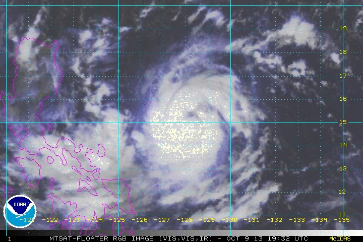
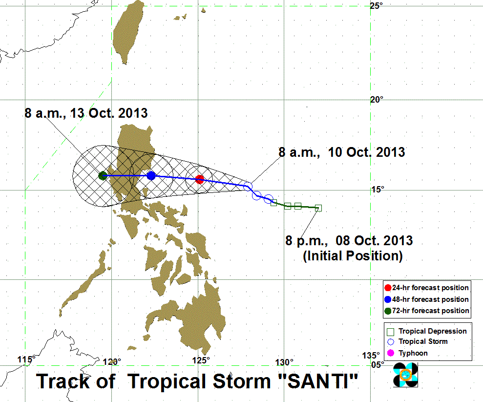
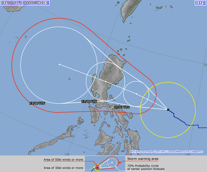
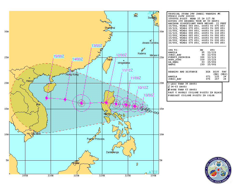
 Click on image to open Satellite Loop! Click on image to open Satellite Loop! SEVERE TROPICAL STORM SANTI (Nari) has further intensified and increased its threat to Luzon as it continues to track West/WNW. SANTI (Nari) may make landfall as a TYPHOON in the coasts between Northern Quezon/Polillio Island and Baler, Aurora by late Friday or early Saturday. All Interests in LUZON should monitor the progress of SANTI (Nari)... All concerned should follow or track the severe weather potential of the storm not just the track of the storm center. Please take note that any shift in the movement of SANTI (Nari) to the north or south of the forecast track can make a HUGE difference on the storm's potential effects in your area. PAGASA STORM WARNING SIGNALS (as of 11 am Warning) SIGNAL NUMBER 1 -- Catanduanes, Camarines Sur, Isabela, Aurora, Quezon, and Camarines Norte ... meaning winds of 45-60 kph are expected in the next 36 hours. At 10 am today (02Z), the center of SEVERE TROPICAL STORM SANTI (Nari) has been located at 15.0°N, 127.7°E, about 410 Km East-Northeast of Virac, Catanduanes... or 650 km North of East of Infanta, Quezon... or 660 km East-Southeast of Baler, Aurora... with Maximum Sustained Winds of 100 KPH (55 KTS) and gusts of 130 KPH (70 KTS)... with that Manila TC considers SANTI (Nari)already a Severe Tropical Storm... SANTI (Nari) is forecast to continue on its WEST to WEST-NORTHWEST track at 13 KPH towards Eastern Luzon. More at the jump so click READ MORE 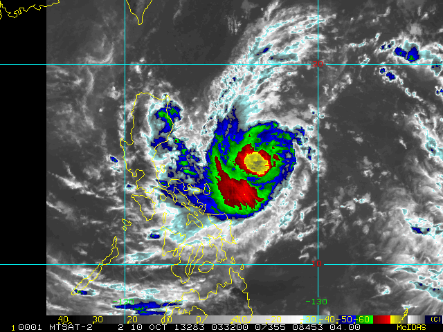 INTENSITY ESTIMATES BY WEATHER AGENCIES PAGASA-Manila -- Max 95 kph Gust 120 kph (10 min-average) CMA-Beijing -- Max 90 kph Gust 110 kph (10 min-average) JMA-Tokyo -- Max 85 kph Gust 105 kph (10 min-average) KMA-Seoul -- Max 95 kph Gust 115 kph (10 min-average) JTWC-Hawaii -- Max 110 kph Gust 140 kph (1 min-average) CWB-Taiwan -- Max 85 kph Gust 105 kph (10 min-average) SANTI (Nari) is expected to intensify into a Typhoon by tonight and continue on its present Westerly course toward Central Luzon over the weekend and be a Category 2 Typhoon with 145 KPH winds upon landfall. Potential Landfall areas are between Northern Quezon all the way up to Aurora province. Its effects are to be felt in the Bicol Region, Central Luzon, southern parts of Northern Luzon, CALABARZON and Metro Manila.
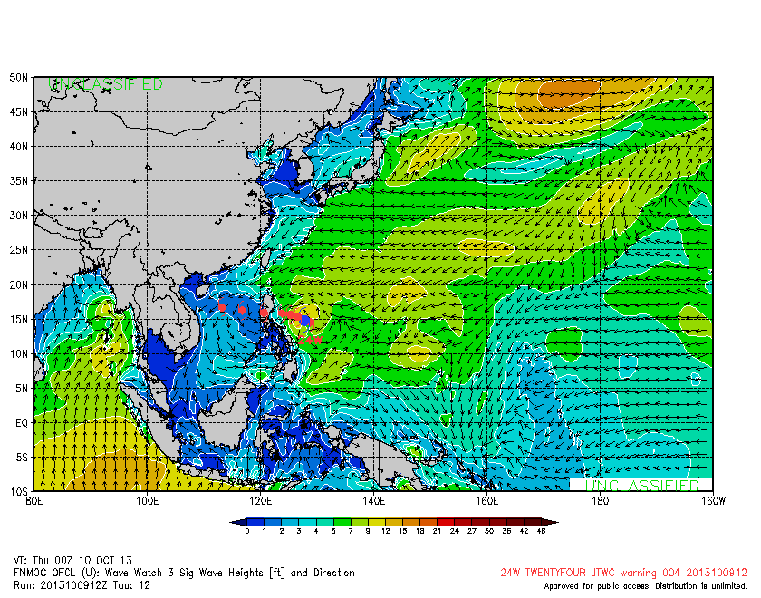
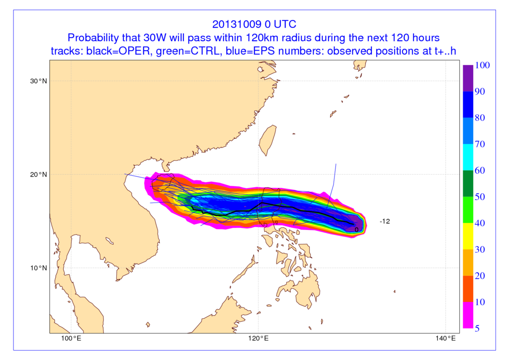
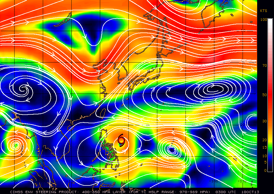
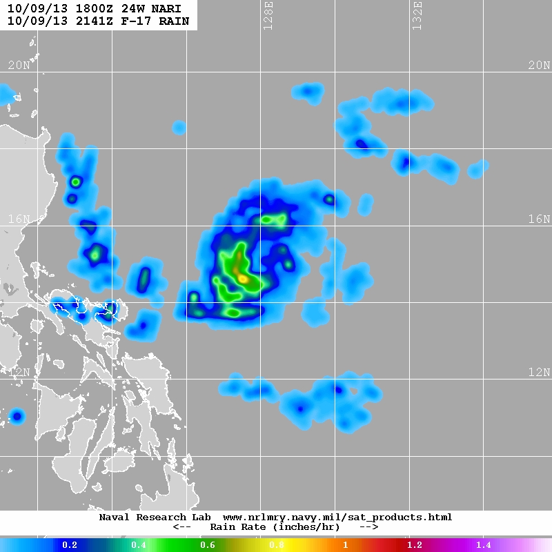
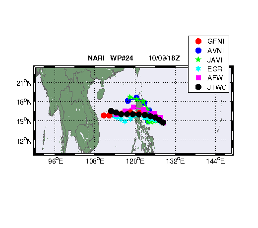 Computer model tracks Computer model tracks TRACK DISCUSSION SANTI (Nari) is expected to intensify into a Typhoon by tonight and continue on its present Westerly course toward Central Luzon over the weekend and be a Category 2 Typhoon with 145 KPH winds upon landfall. Potential Landfall areas are between Northern Quezon all the way up to Aurora province. Its effects are to be felt in the Bicol Region, Central Luzon, southern parts of Northern Luzon, CALABARZON and Metro Manila. The storm will then exit out into the West Philippine Sea over the coasts of Zambales and Pangasinan by Sunday. To have an idea on what to experience during a typhoon's passage read this article (What its like to experience a Typhoon on the ground) POTENTIAL STORM EFFECTS Radius of Gale-force winds is 200 km... Radius of Maximum winds is 55 km from the center of the Storm... Current rainfall estimates show that SANTI (Nari) range from 5-8 mm (moderate) within the Outer rainbands to as much as 15-25 mm (heavy-intense) within the inner rainbands or the core of the storm... Please take note that hours prior/during landfall, Orographic (landmass) effects may enhance rainfall effects of the storm, and possibility of floods and landslides exist... Maximum wave height is 32 feet... Storm surges are possible along the eastern coast of Luzon. A GALE WARNING is in force from PAGASA, The eastern seaboard of Visayas (Samar and Leyte)... cloudy skies with light to moderate rainshowers and thunderstorms with winds of 52 - 63 kph... expect Rough to very rough seas with 3.4 to 4.5 meters in height...
|
Archives
July 2016
AuthorThis is the official blog page of Manila Typhoon Center. All the latest advisories from ManilaTC will be coursed here should the Facebook page be inaccessible for any reason. Categories
All
|
Manila Typhoon Center - Your online resource for typhoon updates.
 RSS Feed
