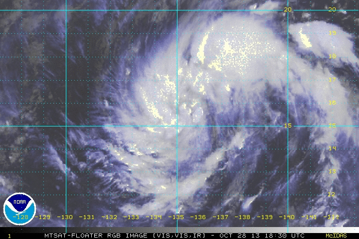
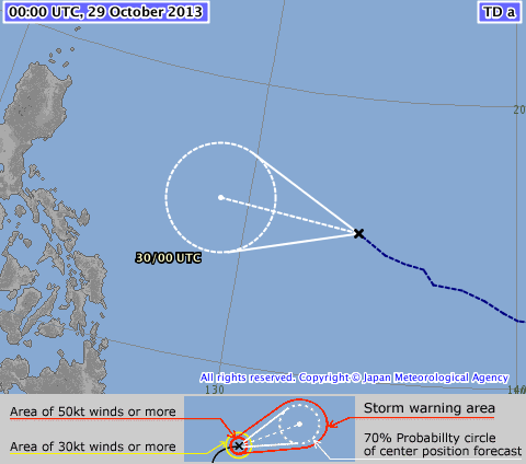
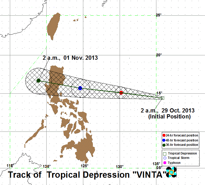
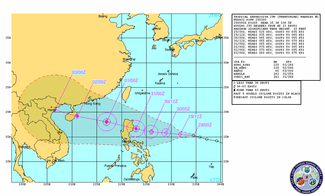
 Click to view Satellite Loop Click to view Satellite Loop Disturbance WP89 (29W) has entered the Philippine Area of Responsibility and at the same time has become the 34th Tropical Cyclone in the Western Pacific as a Tropical Depression. PAGASA-Manila has named the system as VINTA. JMA-Tokyo has been tracking the system since yesterday as well. VINTA is posing a threat to Luzon within the next 3-4 days. NO PAGASA STORM SIGNALS HAVE BEEN RAISED AT THIS TIME. At 8 am today (00Z), the center of TROPICAL DEPRESSION VINTA (TC34) has been located at 15.1°N, 134.2°E, about 1,360 kms East-Southeast of Baler, Aurora or 1,320 kms East-Northeast of Polilio Island in Quezon Province... with Maximum Sustained Winds of 55 KPH (30 Knots) and gusts of 70 KPH (40 Knots)... VINTA (TC34) is currently moving to the WEST at 30 KPH in the general direction of Eastern Luzon... and is expected to become a Tropical Storm within the next 24 hours. Current model tracks depict the storm to track West all throughout the forecast period, towards Eastern Luzon. Residents and Interests on Luzon island should keep watch on the path of this storm, especially those preparing to travel for the All Saints/All Souls day holiday this weekend. ManilaTC
 Click to launch image loop Click to launch image loop UPDATE #2 | FORMATION ALERT
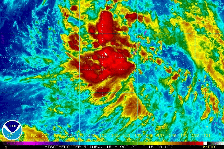
DISTURBANCE #WP89 (INVEST 98W/JMA TD) 0700 AM 2300Z MONDAY 28 OCTOBER 2013 Tropical Disturbance WP89 (98W) has further consolidated and is now subject to a Formation Alert by ManilaTC. JMA-Tokyo, TMD-Bangkok, and CWB-Taiwan consider the system as a full Tropical Depression. At 5 am today, WP89 (98W)'s center of circulation has been located at 12.2°N, 141.3°E... about 450 KM Northeast of Yap Island, Micronesia or 405 KM West-Southwest of Guam, USA... Winds of 45 to 55 KPH (25 to 30 Knots) have been found within the system... WP89 (98W) is moving to the WEST at 25 KPH. WP89 (98W) is forecast to become a Tropical Depression within the day. JMA-Tokyo is pushing for Tropical Storm status after 24 hours. WP89 (98W) is to enter the Philippine AoR by tomorrow and would be named locally as VINTA. If JMA-Tokyo will upgrade to a storm, it will be named KROSA. WP89 (98W) is currently forecast to track towards Luzon and may reach the island by the All Saints Day weekend holiday. Please take note that this forecast are at least a few days ahead and every forecast may change significantly every day. Interests in the Philippines particularly Luzon should take this system into consideration as they make preparations for the All Saints Day holiday weekend. MTC ANALYSIS | The potential of Disturbance WP89 to develop into a Tropical Cyclone within the next 24 hours is now upgraded to LIKELY, with 67% chance. ManilaTC  Click to enlarge Click to enlarge A new Tropical Disturbance has developed Southeast of Guam, USA and has been tagged as WP89 by ManilaTC. LPA WP89 was last spotted at 10°N, 147°E... about 490 km Northeast of Chuuk Island, Micronesia or 520 km Southeast of Guam, USA... Maximum winds within the disturbance are at 25 KPH (15 Knots), and WP89 has tracked to the West at 15 KPH.
WP89 is considered an LPA by JMA-Tokyo, CWB-Taiwan, TMD-Bangkok, BoM-Sydney, and NWS-Guam. This disturbance is unanimously forecast by computer models to develop into a Tropical Cyclone, with JMA pushing the system to become a Tropical Depression in the next 24 hours. Looking forward, LPA WP89 is forecast to track West/WNW and may affect or hit Luzon during the All Saints Day holiday weekend. Please take note that this forecast is 4-5 days ahead and may change significantly every day. MTC ANALYSIS | The potential of Disturbance WP89 to develop into a Tropical Cyclone within the next 24 hours is MEDIUM, with 49% chance. ManilaTC 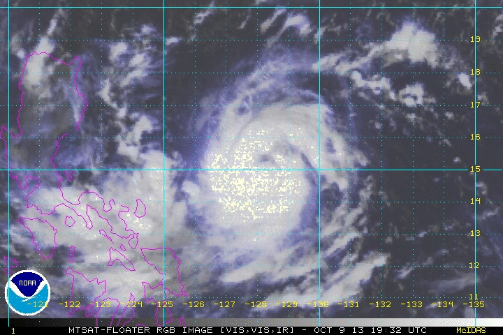 Click on image to open Satellite Loop! Click on image to open Satellite Loop! SEVERE TROPICAL STORM SANTI (Nari) has further intensified and increased its threat to Luzon as it continues to track West/WNW. SANTI (Nari) may make landfall as a TYPHOON in the coasts between Northern Quezon/Polillio Island and Baler, Aurora by late Friday or early Saturday.
All Interests in LUZON should monitor the progress of SANTI (Nari)... All concerned should follow or track the severe weather potential of the storm not just the track of the storm center. Please take note that any shift in the movement of SANTI (Nari) to the north or south of the forecast track can make a HUGE difference on the storm's potential effects in your area. PAGASA STORM WARNING SIGNALS (as of 11 am Warning) SIGNAL NUMBER 1 -- Catanduanes, Camarines Sur, Isabela, Aurora, Quezon, and Camarines Norte ... meaning winds of 45-60 kph are expected in the next 36 hours. At 10 am today (02Z), the center of SEVERE TROPICAL STORM SANTI (Nari) has been located at 15.0°N, 127.7°E, about 410 Km East-Northeast of Virac, Catanduanes... or 650 km North of East of Infanta, Quezon... or 660 km East-Southeast of Baler, Aurora... with Maximum Sustained Winds of 100 KPH (55 KTS) and gusts of 130 KPH (70 KTS)... with that Manila TC considers SANTI (Nari)already a Severe Tropical Storm... SANTI (Nari) is forecast to continue on its WEST to WEST-NORTHWEST track at 13 KPH towards Eastern Luzon. More at the jump so click READ MORE |
Archives
July 2016
AuthorThis is the official blog page of Manila Typhoon Center. All the latest advisories from ManilaTC will be coursed here should the Facebook page be inaccessible for any reason. Categories
All
|
Manila Typhoon Center - Your online resource for typhoon updates.
 RSS Feed
