A new tropical disturbance has formed south of Guam. The Naval Resources Laboratory (NRL-USA) has tagged the system as INVEST 99W. The Japan Meteorogical Agency (JMA) and Taiwan's Central Weather Bureau (CWB) has upgraded INVEST 99W as a minor Tropical Depression in their morning bulletins. Currently, INVEST 99W is located at 7.0N 143.8E, about 730 km South-Southeast of Guam or 685 km East-Southeast of Yap Island. The system has winds of 20-25 kts (35-45 kph) based on Japan Meteorogical Agency (JMA) estimates. INVEST 99W is currently quasi-stationary. Based on available computer models, they unanimously agree that INVEST 99W will become a Tropical Cyclone and is forecast to track to a West-Northwest or Northwesterly direction towards Taiwan early or mid next week. INVEST 99W is currently not forecast to directly affect the Philippines, but could enhance Southwest Monsoonal flow next week. ManilaTC gives INVEST 99W, based on current data, a MEDIUM CHANCE of developing into a Tropical Cyclone at 53% within the next 24 hours. 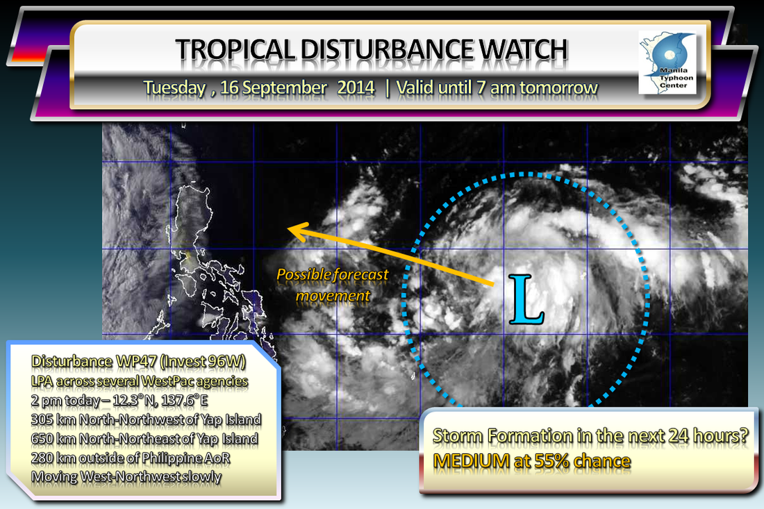
ManilaTC is now monitoring another Tropical Disturbance -- 280 km Outside the Philippine Area of Responsibility, east of Samar Island.
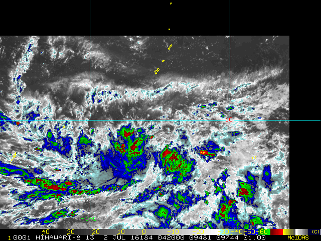
Disturbance WP47 (Invest 96W) has shown more organization over the last 12 hours. It is currently drifting to the West/WNW and may enter the PAR tonight or early tomorrow. Forecast models are mixed on developing this system. ManilaTC will keep monitoring the system and will post the next update tomorrow, unless major developments occur.
Tropical Disturbance WP54 (91W)'s potential development into a Tropical Cyclone within the next 24 hours is now UPGRADED from Likely to HIGH, now with 73% chance. -- ManilaTC  The Japan Meteorological Agency has upgraded WP54 (91W) as a full Tropical Depression, moving North-Northwest at 7kph.
** WTPQ20 RJTD 250000 *** RSMC TROPICAL CYCLONE ADVISORY NAME TD ANALYSIS PSTN 250000UTC 11.0N 129.5E POOR MOVE NNW SLOWLY PRES 1004HPA MXWD 030KT GUST 045KT FORECAST 24HF 260000UTC 14.2N 128.3E 120NM 70% MOVE NNW 09KT PRES 996HPA MXWD 035KT GUST 050KT ManilaTC is now issuing a Tropical Cyclone Formation alert for Disturbance WP54 (Invest 91W) located east of Samar province.  Tropical Disturbance WP54 (Invest 91W) has shown further organization and is now subject to a Formation Alert by ManilaTC. At 0200am today, WP54 (Invest 91W) was last located at 10.9°N, 130.8°E... about 550km East of Guiuan town in Eastern Samar, Philippines. Maximum winds near the disturbance center are at 35 kph (20 kts), and has drifted to the Northwest to Computer models are in unanimous agreement to develop WP54 (Invest 91W) into a tropical cyclone within the next 24 hours and to track Northwest across the Northern Philippine sea... potentially towards Extreme Northern Luzon. Should PAGASA upgrade this disturbance, it will be named Nando. ManilaTC analyzes that Tropical Disturbance WP54 (Invest 91W)'s potential development into a Tropical Cyclone within the next 24 hours is LIKELY, with 63% chance. #ManilaTC #TyphoonWatch #HabagatWatch #StormWatch |
Archives
July 2016
AuthorThis is the official blog page of Manila Typhoon Center. All the latest advisories from ManilaTC will be coursed here should the Facebook page be inaccessible for any reason. Categories
All
|
Manila Typhoon Center - Your online resource for typhoon updates.
 RSS Feed
